Wärtsilä iSailor
Wartsila Voyage Sweden AB
2.5
Versionsdetails
| Herausgeberland | DE |
| Veröffentlichungsdatum im Land | 2010-12-15 |
| Kategorien | Travel, Navigation |
| Länder / Regionen | DE |
| Entwickler-Website | Wartsila Voyage Sweden AB |
| Support-URL | Wartsila Voyage Sweden AB |
| Inhaltsbewertung | 4+ |
Wärtsilä iSailor is an easy-to-use marine and river navigation application for amateur seafarers.
iSailor provides a clear presentation of navigational information, electronic charts and additional content.
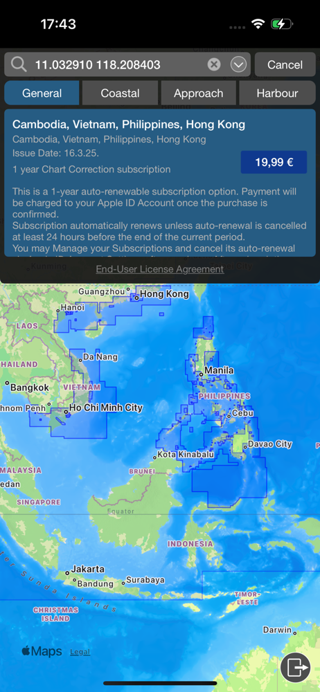
TX-97 vector charts supported by iSailor are recognized worldwide as one of the most accurate and reliable sources of navigational information.
Check out the chart folios available for purchase on our website: isailor.us
Chart folios can be purchased and downloaded in the iSailor Chart Store utilizing the standard iTunes Store payment/purchasing procedure. Chart correction service is provided on annual basis via the auto-renewable subscription service. iTunes will charge payment after confirmation of the chart correction purchase. You may manage your subscriptions and turn off the auto-renewal service in the Account Settings. Your subscription will automatically renew unless auto-renewal is turned off at least 24 hours before the end of the subscription period. You can cancel your subscription in the Chart Store any time. All previously purchased chart folios will remain available for you and can be restored from the service via the Chart Restore function. To receive subsequent chart corrections for your purchased charts, you will need to subscribe to the annual updates in the Chart Store.
The application works on iPhone and iPad using built-in GPS, NMEA Wi-Fi GPS or an external Bluetooth GPS.
Supported devices (iOS version 11 and higher):
• iPhone 5S or higher
• iPad - 5nd generation or higher
iSailor features:
• Positioning system: iOS (Built-In GPS), NMEA GPS or AIS Class B (Option)
• AIS Class A NavData interface (Option)
• NMEA Heading and Rate-Of-Turn sensors (Option)
• NMEA Echo Sounder with a graphical 2D echogram and water temperature sensor (Option)
• NMEA Wind Sensor, including True & Relative wind calculation (Option)
• NMEA Autopilot interface (Option)
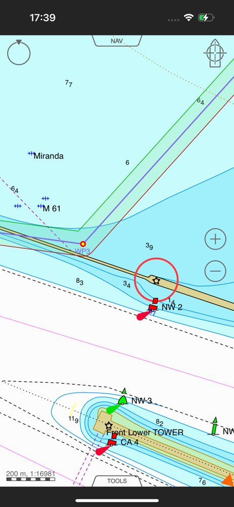
• Display of charts, routes, track(s) and user objects
• AIS target presentation. Target contours and dimensions (Option)
• Internet AIS service (Optional subscription)
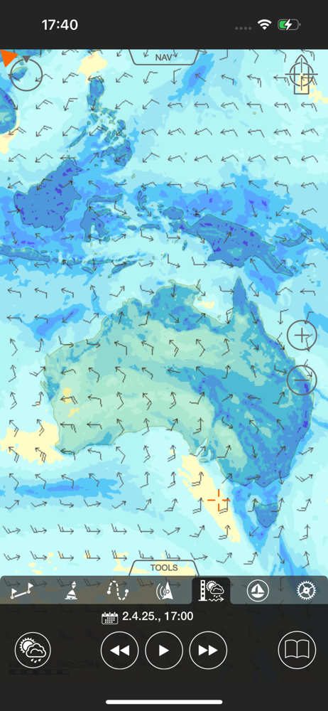
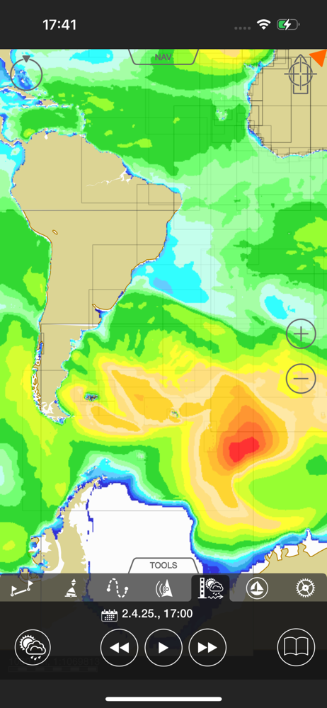
• Weather service (Optional subscription)
• Tides and tidal currents (Optional subscription)
• Sailing guides, regional marinas (Optional subscription)
• North Up, COG Up, Head Up and Route Up chart orientations
• Information on any vector chart objects
• Free cursor, Point-To-Point and Own ship referenced ERBL functionality
• Monitoring of navigational data: Position, Course (COG) and Speed Over Ground (SOG)
• Route creation by the graphic and tabular methods. “Go To” routes.
• Waypoint monitoring: Bearing to WP, Distance to WP, XTD, Time-To-Go and ETA
• Schedule information: Time-To-Go and ETA to any selected waypoint ahead
• Multi-language support
• Multi-unit support
• Custom track colors
• Day and night chart palettes
• Alarm monitoring functionality
• Route, track and user object: export/import via GPX, KML and KMZ formats
• Advanced Logging and Playback function (Option)
• User object sharing via Facebook, Twitter, iMessenger, eMail
NOTE: Continuous use of the GPS running in the background can dramatically decrease the battery life. Wärtsilä iSailor application may use your location even when it’s not open, which can decrease battery life of the device
iSailor web site: http://www.isailor.us
iSailor EULA: https://www.wartsila.com/docs/default-source/marine-documents/transas/WVL-EULA.pdf
iSailor Privacy Notice: https://www.wartsila.com/legal-privacy/privacy
Questions? Please contact us at [email protected]
Sincerely yours,
iSailor Team
Durchschnittsbewertung
17
Bewertungshäufigkeit
Ausgewählte Bewertungen
Von Matthes0987
2025-09-10
Version 1.12.2
performance_and_bugsfeature_requestsIch bin ja eigentlich begeistert von der App aber das gekaufte Karten nicht runterladen werden können ist echt schade. Bitte diesen Fehler beheben!
Von Auto-Doc
2025-08-30
Version 1.12.2
updates_and_maintenanceperformance_and_bugscustomer_supportpaymentUpdate: nach Info vom Entwickler, funktioniert der Download! Ob mich die Software beim segeln überzeugt, kann ich noch nicht sagen,aber auf den ersten Blick,sieht es sehr gut aus. Ich finde es ja schon mal sehr lobenswert, das es eine Info gab, dass es wieder funktioniert!!! Danke dafür Nach dem Kauf der Ostseekarte konnte ich sie nicht herunterladen. Rückerstattung hat über den Apple Support glücklicherweise geklappt, sonst wären die 40 Euro für die Tonne gewesen.
Von ö!!!!!!!!!!
2025-09-16
Version 1.12.2
designcustomer_supportDie App funktioniert überwiegend so wie sie soll. Leider wird auf meinem iPad der Button zur Registrierung wodurch kein Kontakt zum Support möglich ist.
Screenshots