HuntStand
TerraStride Inc.
4.6
AD
Release Details
| Publisher Country | US |
| Country Release Date | 2018-04-14 |
| Categories | Sports |
| Country / Regions | US |
| Developer Website | TerraStride Inc. |
| Support URL | TerraStride Inc. |
| Content Rating | 4+ |
AD
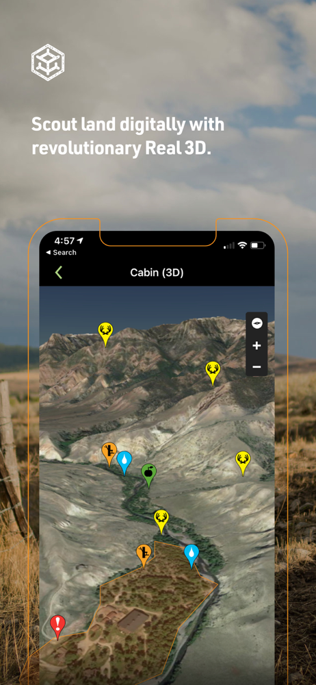
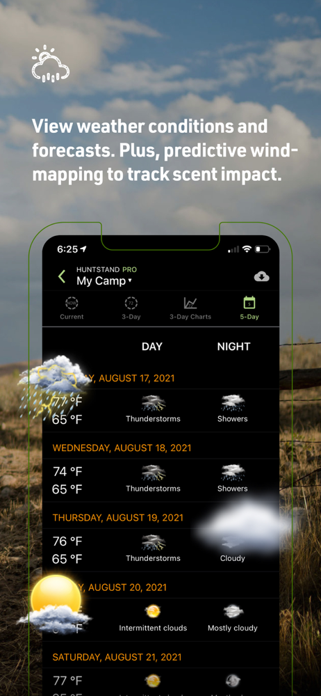
Recognized by Outdoor Life Magazine as the Best Hunting App available. With over 6 million downloads, HuntStand is North America’s #1 Hunting & Land Management App. Map and navigate your hunting areas in real 3D, view detailed hunting weather and game movement forecasts, access private and public property info, view 5 years of historical satellite imagery by month and so much more. Try HuntStand for free today, and unlock even more powerful features through our membership options.
What Sets HuntStand Apart?
• Rich 3D Mapping: Navigate your hunting terrains in dynamic 3D for precision planning.
• Group Hunt Areas: Collaborate seamlessly, sharing hunt areas with hunting buddies, lease partners, and family members.
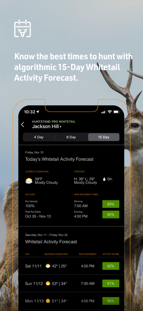
• Advanced Weather & Game Movement Forecasts: The latest science informs our exclusive 15-Day Whitetail Activity Forecast specific to your Hunt Area. Know when to hunt.
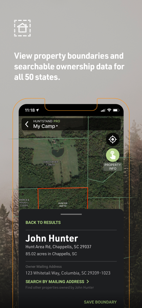
• Extensive Property Line Insights: Dive deep into private and public property details with nationwide private property boundaries and curated public land and public hunting land maps.
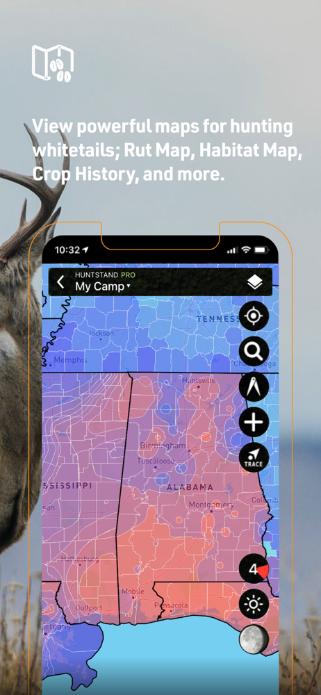
• Nationwide Rut Map: The only nationwide county-level rut map available, providing rut dates for all phases. Visualize comprehensive rut data through a color-coded map to make sure you’re putting the right strategies to work.
With a Free Account, Enjoy:
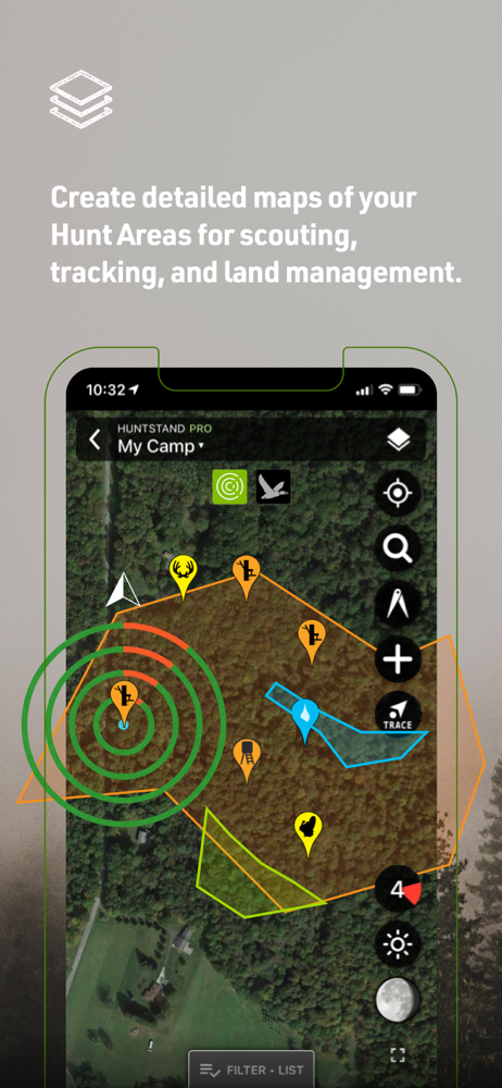
• High-Resolution Aerial Imagery: Craft detailed maps of your hunting areas.
• Stealth Cam & Muddy Trail Camera Integration: View and manage your trail cameras effortlessly within the app.
• Comprehensive Weather Forecasts: Stay ahead of the weather and optimize your hunting plans.
• Advanced Stats: Delve into personal harvest and sighting analytics for richer insights.
• Nationwide Crop History Maps: Access current and historical crop data to refine your strategy.
• Stand Reservation Management: Systematically organize stand hunting times within shared hunt areas.
Upgrade Options - HuntStand Pro & HuntStand Pro Whitetail:
HuntStand Pro Benefits:
• Nationwide Property Boundaries: Offering coverage across the U.S. and most of Canada, with unlimited U.S. property ownership searches.
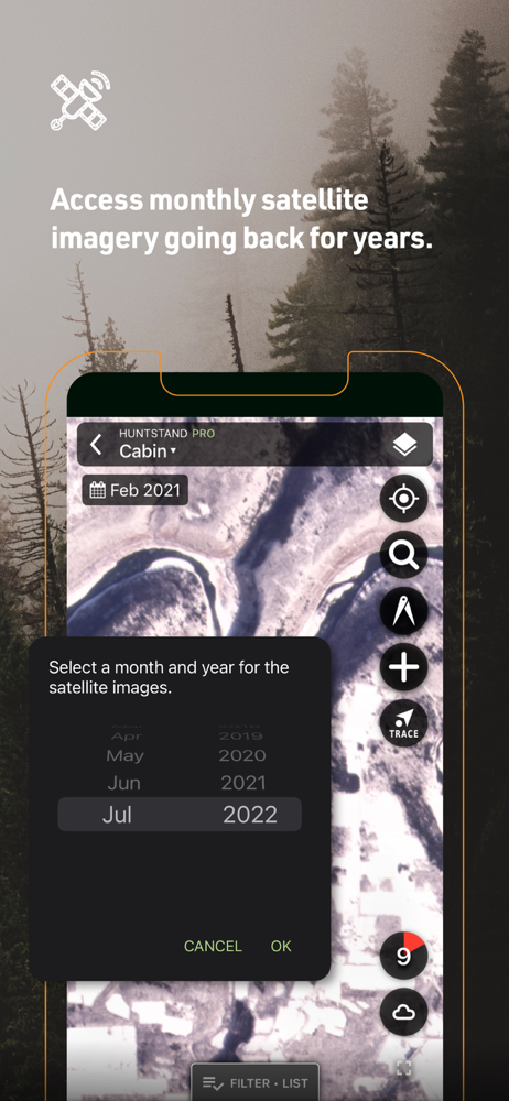
• Recent Satellite Imagery: Retrace changes in your hunting ground with monthly satellite imagery, dating back to 2018.
• Real 3D Maps: Dive into your maps in full 3D on both mobile and desktop.
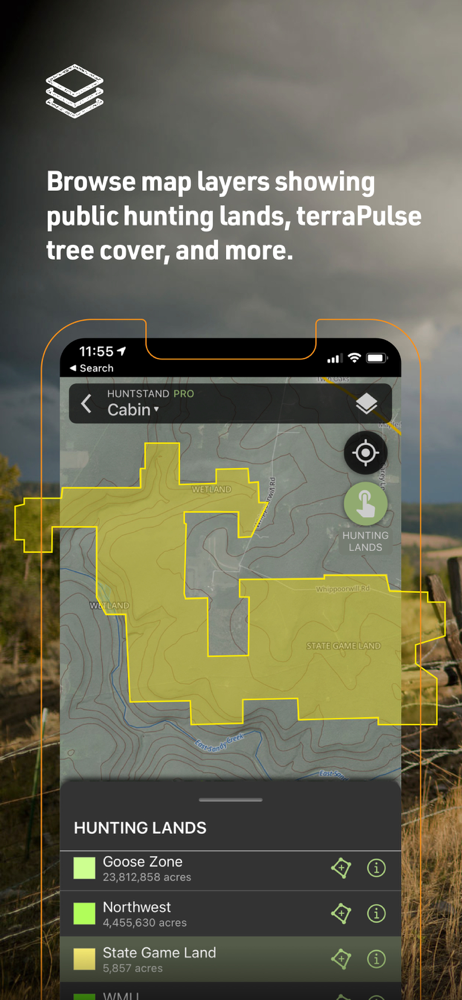
• Land Data Layers: A spectrum of details including hunting lands, public lands, crop history, tree cover, and more.
• Real-time Weather Radar: Anticipate weather changes with real-time updates.
HuntStand Pro Whitetail Exclusives:
• All the features of HuntStand Pro.
• Nationwide Rut Map: Boasting the most comprehensive county-level rut data visualized on a color-coded rut map.
• Whitetail Activity Forecast: Get a grip on deer movement with a 15-day predictive outlook and in-depth metrics.This exclusive feature uses data from state agencies and top whitetail scientists.
• Whitetail Habitat Map: Gain unparalleled insights into top habitats optimal for white-tailed deer. Find new hunting areas with ease!
Billing & Subscription: Charges apply to your iTunes Account upon purchase confirmation.
Privacy Policy: https://huntstand.com/privacy
Terms & Conditions: https://huntstand.com/terms-and-conditions
Average Rating
58.06K+
Rating Breakdown
Featured Reviews
By 58 Tim
2023-10-20
Version 7.4.3
HuntStand is the only hunting app I use and I’ve been using it for several years! Had a guy come up to me and said I was hunting on their land. I brought up the boundary lines for the farm I was hunting on and then his. He didn’t (couldn’t) say anything but I was clearly 50 to 75 yards inside the farm boundary and facing away from his property. I told him thank you for ruining my evening hunt. I never put up a stand I know is going to be close to a boundary without using HuntStand. I want to be at least 50 yards off another person’s land, up high, with my back to the tree, and the tree between me and the boundary… you never know who’s over there hunting as well. HuntStand maps are by far the best and have good historical imagery. The ability to identify wind direction (Hunt Zone) at your stand is crucial and I find HuntStand is pretty much right on. Yes I know thermals up in the morning down in the evening but you can still see scent drift direction. You may be different or your area may be different but as for me… I’ll take HuntStand over any other app out there everyday of the week. It just works for me and I couldn’t be any happier with it!
By Steph AR
2023-06-02
Version 7.3.0
AdsLove itNetworkAwesome management tool for measuring distances, calculating plant areas and off line mapping and boundary marking/outlines. Also, the most accurate public land mapping app with descriptive notations regarding specific regulations within WMAs (i.e. Natural Areas, Special Use Areas -SUA, Walk-In Turkey Areas etc). (I’ve tested OnX, Base Map, Spartan Forge and Hunt Wise) While some may offer zone regulations and web links they do not detail the special areas’ boundaries where Hunt Stand does! Also, the imagery is the best I’ve found while online and the monthly sat images are convenient as well. I also love how you can toggle between topo lines, property lines, public land details and various other maps while keeping your same spot on the map whether you are online or off! All you have to do is be sure you save your hunt area before heading out. Last, the weather features and wind tools are great too. I’ve literally tested every app, this one is as close as you’ll find for covering all bounds, unless you’re interested in aquatic telemetry. Get this, and don’t go through all the others like I did… some have better “marketing”, but this takes the prize for practicality and functionality.
By Standing Goats Rescue on YT
2023-02-11
Version 7.1.8
Feature RequestsLocationLove itPricingSpendingI’ve been using HuntStand for a couple of years now, I’m using the paid version for the extra features it offers. My entire hunting party uses it too because we can link to each other and we always know where each other is located. The only gripe that all of us have is that it really really needs a “Go To” function. What I’m referring to is the waypoints…it would be a perfect app if it had the ability to lead you to whatever waypoint you select. Here’s an example: find the waypoint you want to navigate to, click on it on the map, then click “Go To” and it will then show you where to go….by showing a pointer and compass heading to give you the direction and distance to the waypoint you select. This feature is available on all fishing gps units, but it would be an incredibly useful feature if HuntStand offered it on the app. Besides this one gripe, HuntStand is certainly in the top 5 hunting apps available. If we had a “Go To” feature on it, it would easily be the number one hunting app on the market. If you haven’t tried HuntStand yet, it’s certainly worth giving it a shot! Thanks for a nice hunting tool!
Screenshots
AD
AD