Ventusky: Weather & Live Radar
Ventusky s.r.o.
4.8
Release Details
| Publisher Country | US |
| Country Release Date | 2017-09-12 |
| Categories | Weather, Travel, Education |
| Country / Regions | US |
| Support URL | Ventusky s.r.o. |
| Content Rating | 4+ |
Ventusky All-in-One Weather is a fusion of 20+ of the world’s best models, live radar, satellite and 40,000+ webcams, delivering industry-leading accuracy for planning everything from morning jogs to transatlantic flights.
WE BRING A UNIQUE SET OF FEATURES LIKE:
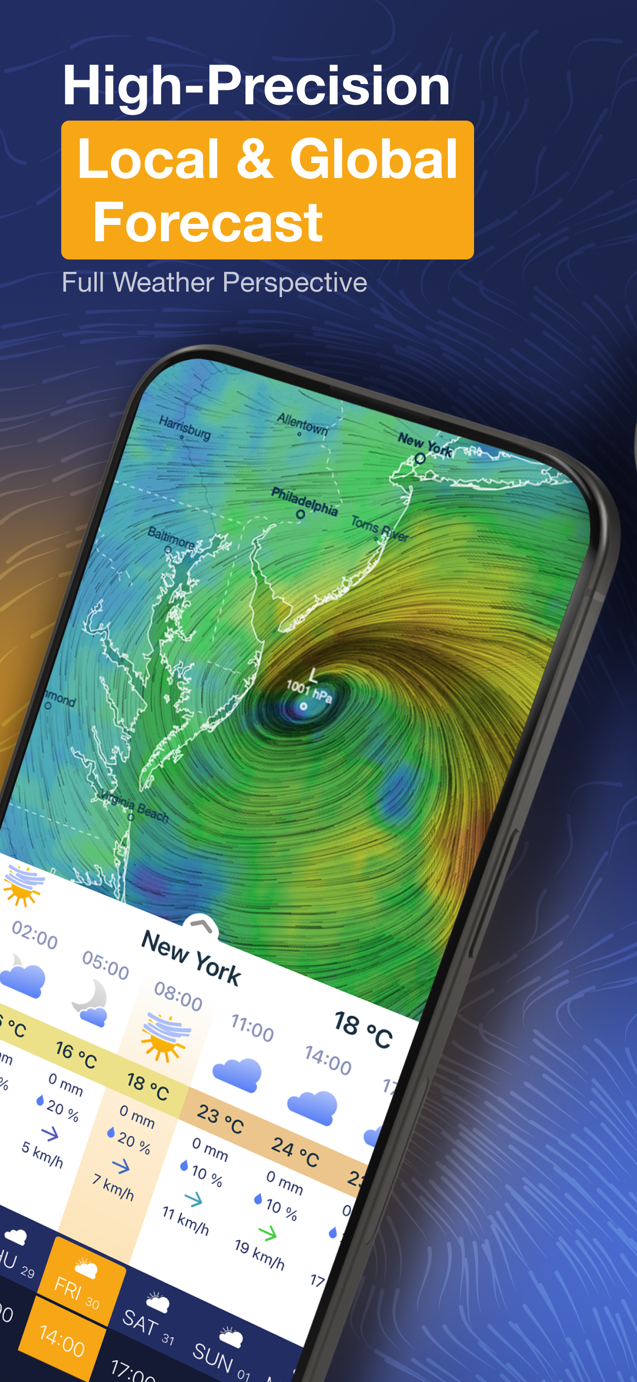
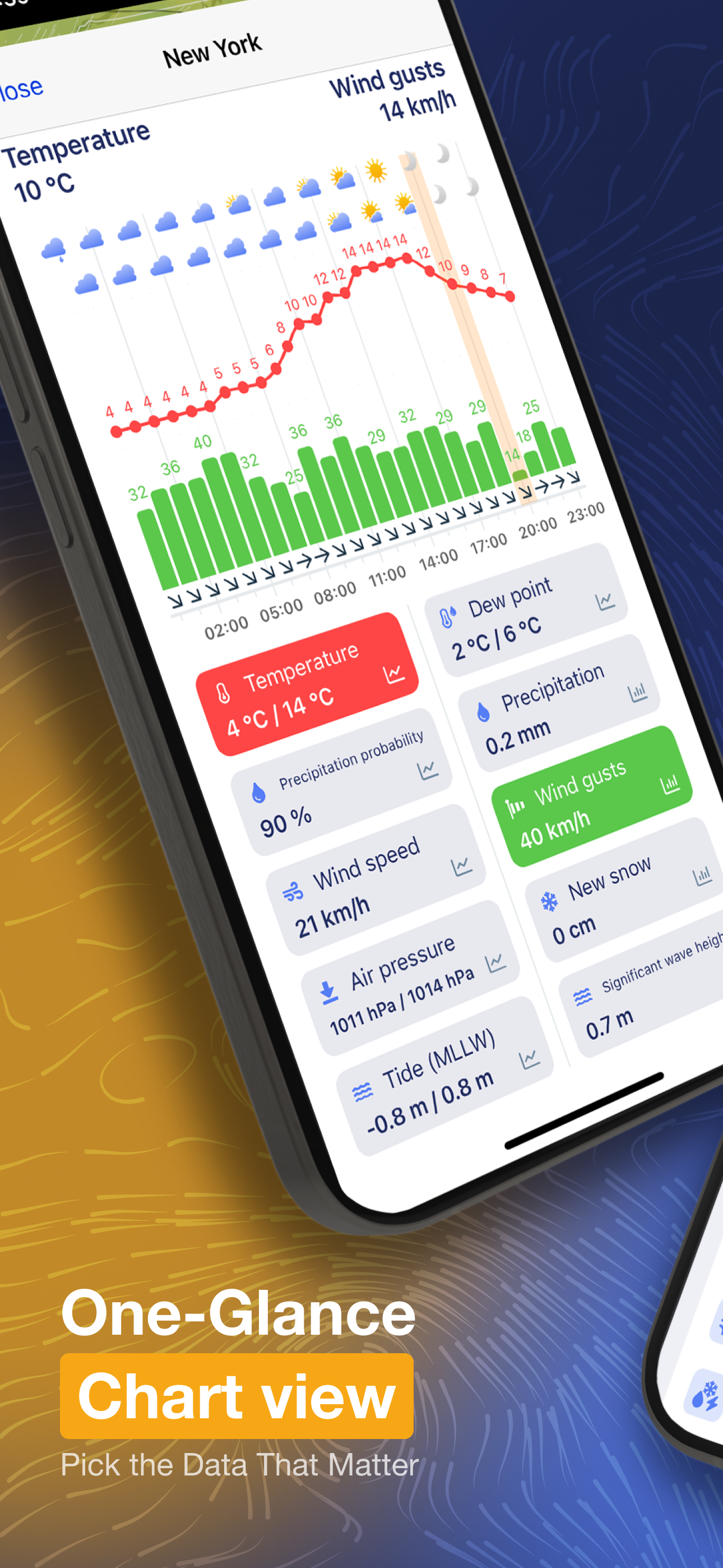
- Hyperlocal 14-days weather forecast with up to hourly resolution
- 80+ weather maps
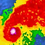
- Live radar and lightnings detection
- 40,000+ worldwide webcam coverage
- Lock and home screen widgets with forecasts, webcams, or radar
- Integration with Watch OS
- 3D interactive globe
- Customizable push notifications for: wind, waves, freezing rain, pressure, lightning strikes, umbrella reminder or morning/evening summary.
- Professional features like isolines or weather fronts
- Dual wind animations for 2 different altitudes
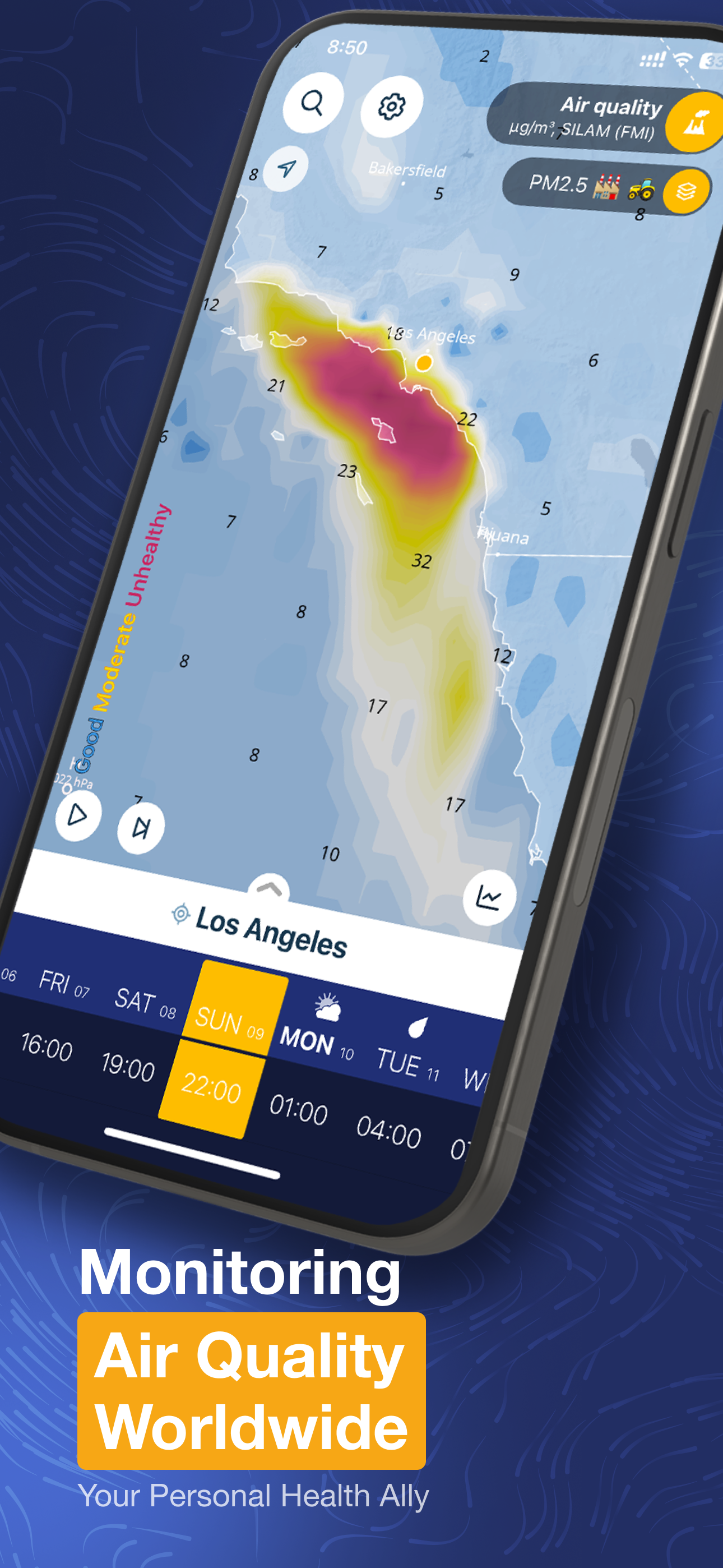
- Extensive air quality information
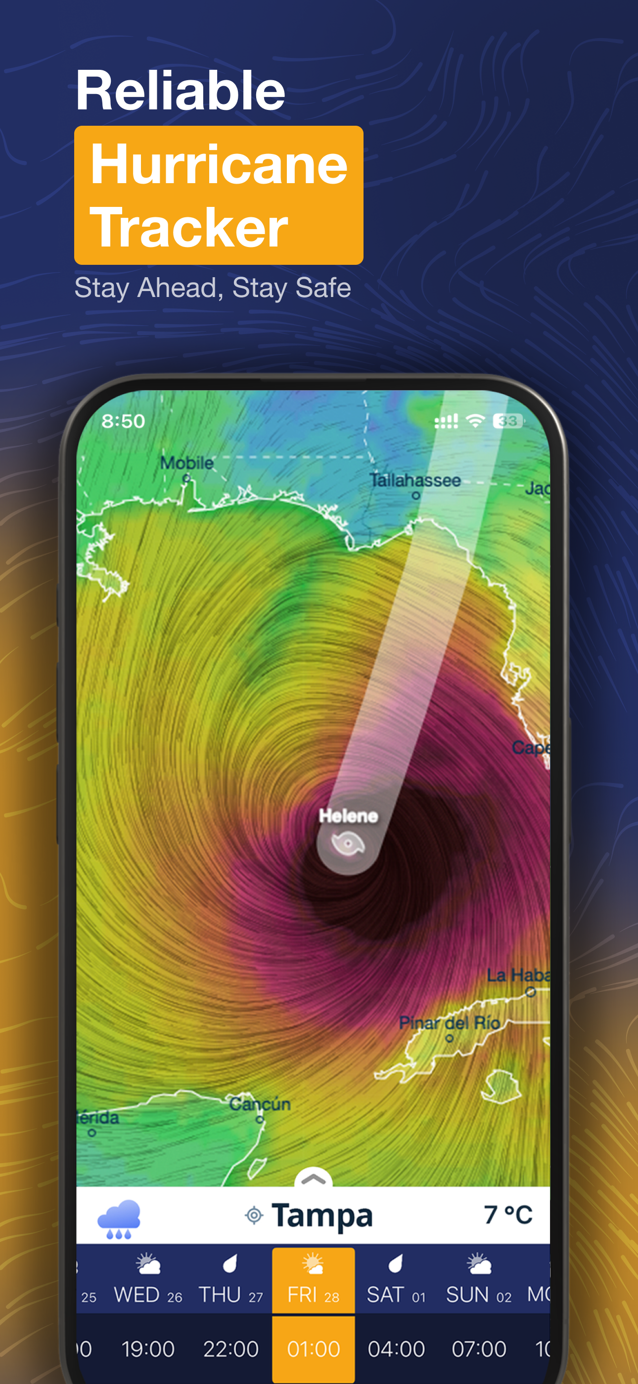
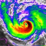
- Hurricane and storm tracking - compare tracks from multiple models and stay safe
Use Ventusky everyday to plan your activities and stay ahead of the weather:
1) Joggers & Outdoor Athletes: Plan with Microscale Precision
For runners, cyclists, and hikers, Ventusky provides updates critical for avoiding sudden weather shifts.
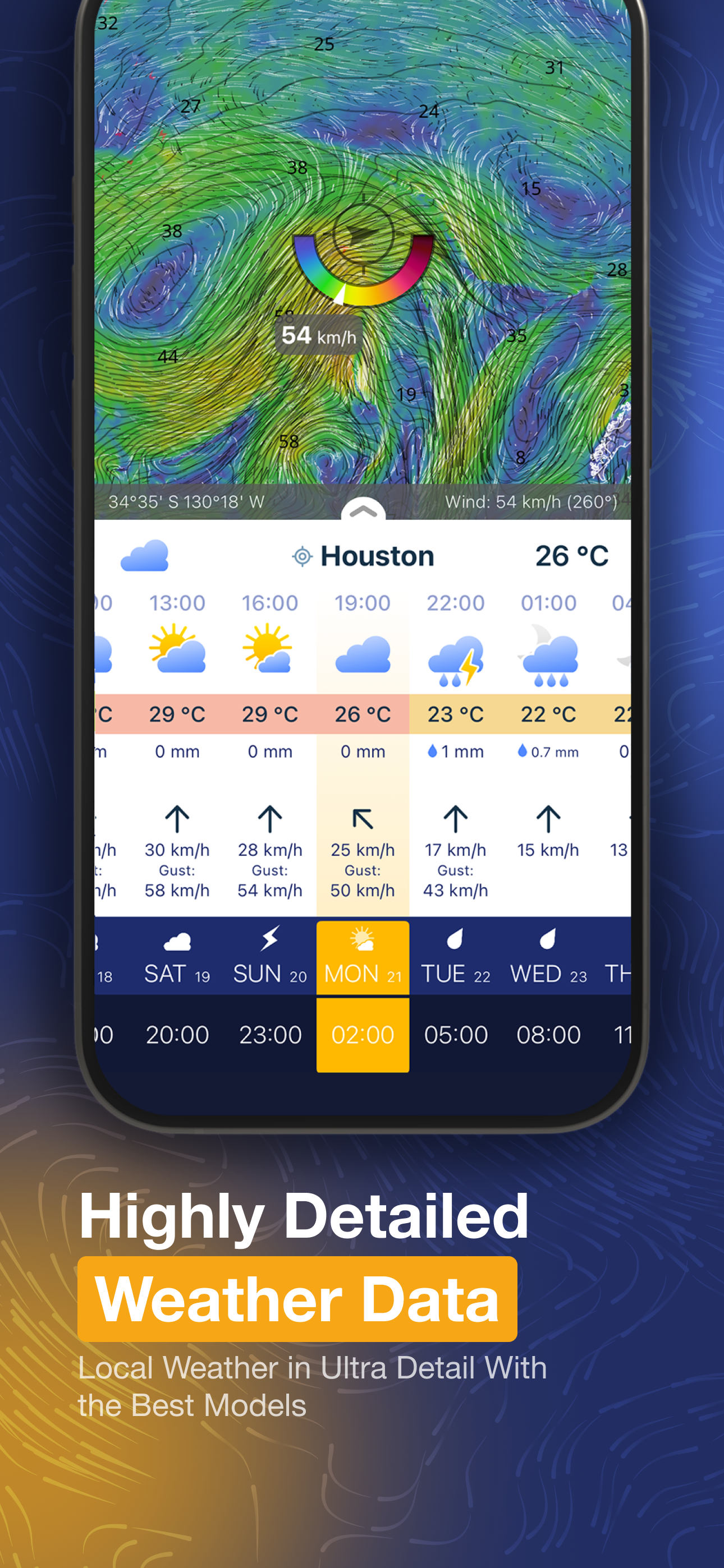
Hyperlocal Wind Gust Maps: Visualize wind speed changes at high resolution, ideal for route planning in mountainous regions.
Lightning Strike Alerts: Receive push notifications for strikes within selected distance, synced to wearable device haptics for hands-free safety.
Feels-Like Temperature: Combines humidity, wind chill, and solar radiation to advise on heatstroke risks during summer runs.
2) Vacation Planners: Verify Conditions in Real Time
Travelers leverage global webcam network and 14-day forecasts to optimize itineraries.
Live Cams: Compare real-time footage from 40K+ coastal, ski resort, and urban cameras to assess conditions before departure.
Tropical Storm Preparedness: Track hurricanes predicting storm paths and landfall in advance.
Air Quality Indexes: Plan trips using SILAM model data on PM2.5, NO2, ozone levels and more.
3) Meteorologists & Professionals: Industrial-Grade Tools
Ventusky serves as a field toolkit for pilots, sailors, and researchers needing altitude-stratified data:
Aviation Wind Layers: Animate wind patterns at 16 altitudes (0m–13km) for flight path optimization.
Marine Forecasting: Access ocean current models and surge predictions for offshore operations.
Agricultural Planning: Display the monthly anomaly in precipitation in easy to use map.
MULTI-MODEL FUSION FOR UNMATCHED ACCURACY
Why Does Ventusky Outperform Competitors? Ventusky’s algorithms integrate data from the world’s most advanced numerical weather prediction (NWP) systems, each renowned for specialized applications. In addition to the well-known ECMWF and GFS models, it also displays data from the German ICON model, which stands out for its high resolution covering the entire world. A wide range of high-precision local models is available. Some are updated as frequently as every 10 minutes based on radar and satellite readings, providing highly accurate real-time precipitation data. Ventusky automatically selects the most precise model for your location, but you can also compare them yourself.
LIST OF WEATHER LAYERS:
Temperature (16 altitude levels)
Feels like temperature
Precipitation (1 hour, 3 hours, cumulated, monthly anomaly, Freezing rain, Rain, Snow)
Radar and lightnings
Satellite
Wind gusts
Air Quality (PM2.5, PM10, NO2, SO2, O3, CO, Dust, AQI)
UV-index
Probability of Aurora
LIST OF WEATHER LAYERS (PREMIUM)
Cloud coverage (High, Mid, Low, Base, Total cover, Fog)
Wind speed (16 altitude levels)
Air pressure
Thunderstorms (CAPE, CAPE*SHEAR, Wind shear, CIN, Lifted index, Helicity)
Sea (Significant, wind and swell waves period and height, Currents, Tidal currents, Tide, surge)
Humidity (4 altitude levels)
Dew Point
Snow cover (Total, New)
Freezing level
Visibility
The app is completely free of ads or tracking scripts. Do you have questions or suggestions? Visit my.ventusky.com.
Download Ventusky: Weather & Live Radar
Not Available
Average Rating
35.12K+
Rating Breakdown
Featured Reviews
By RyanReviewAppStore
2024-10-18
Version 38
feature_requestsThe big draw for me to this app is being able to quickly select from tons of different layers on the map and then seeing that data globally. And excellent wind information too that shows visually and numerically on the map and you can pick the altitude. So far in using it there is one major missing feature or perhaps I can't find it but I need to check humidity frequently so having a chart of predicted humidity would be really helpful. They have charts / plots for temperature, pressure, etc and you can view humidity on the map but no plot of it. Without that I do still use Apple's weather as it has humidity charts. But for everything else I use Ventusky. Then one minor feature which might not be possible with the data sources / calculations they have right now but if easy to add, would like to be able to see a little plot of tidal information anywhere in the world. As you do have great tide numbers on the map layer but for areas I'm not familiar with I don't know if that means high tide or how much further etc. As going somewhere with a tidal land bridge and don't want to get stuck (obviously I'll check elsewhere but would be sweet in here).
By PolarBearQM
2017-11-02
Version 2.0
performance_and_bugscross_platform_consistencyupdates_and_maintenanceSo far so good. The updates for the initial bugs have really helped. Look forward to the possibility of landscape mode on iPhone. Biggest downfall right now and what keeps me going back to the website instead of the app is there's no wave information in the app. My job is on the water so that's a significant loss in my book. Look forward to seeing that as an addition. *As the developer said in their response to my original review, it would take a bit, but they came through as promised and the wave height has been added with all the other features they've put in so far. It works great! And now information I need daily for work is quickly and easily accessible and I can even get updates while out on the boat if needed as long as we are near shore and get cell service. The app is much smoother to operate on-the-go over the website (not criticizing the website, merely thinking of ease of use on a smartphone) and now has all the features for forecasting a day or several working out on the water. Thank you!*
By 1776% for 2A
2025-06-06
Version 44.1
localizationI’ve had this app for several years. This is not a lowest common denominator weather app. In other words, it’s sophisticated & very accurate. With information and data a professional or avid meteorologist would require. I guess I’m saying it’s not a dumbed down app with averages and general info. I especially like the touch map location change. Touch the map to change your location. I am below the “novice” category user. But I manage to muddle my way through and I’m constantly learning more and more. I probably use the wind speed mode most often. I live in Abbott, AR. near the Arkansas/Oklahoma line called Arklahoma. Where we can have high and gusting winds 30 to 60 mph. Sometimes higher… Not to mention tornado activity. Especially in the spring.
Screenshots