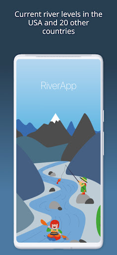
RiverApp - River levels
Florian Bessière
4.9
Detalles de la Versión
| País del Editor | US |
| Fecha de Lanzamiento en el País | 2013-09-19 |
| Categorías | Weather |
| Países / Regiones | US |
| Sitio Web del Desarrollador | Florian Bessière |
| URL de Soporte | Florian Bessière |
| Clasificación de Contenido | Everyone |
Get quick access to the latest water levels and river flows for rivers in the USA and 20 other countries around the world.
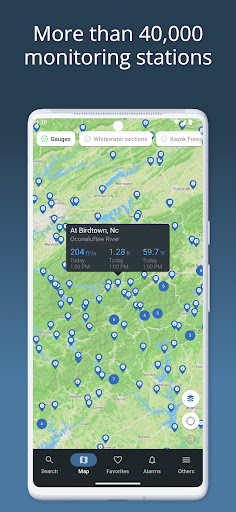
RiverApp is the application that contains data from the largest number of hydrometric stations in the world, with over 40,000 sites.
RiverApp is the ideal application for all river-related sporting or professional activities: kayaking, canoeing, pack rafting, stand-up paddling, fly fishing, river surfing, hydroelectricity, irrigation, etc.
It’s also very useful for monitoring the evolution of rivers in the event of flooding.
FREE FEATURES:
‣ Current water levels and flows in over 15,000 rivers in the US and around the world.
‣ Water temperatures.
‣ Detailed maps of hydrometric stations and whitewater sections.
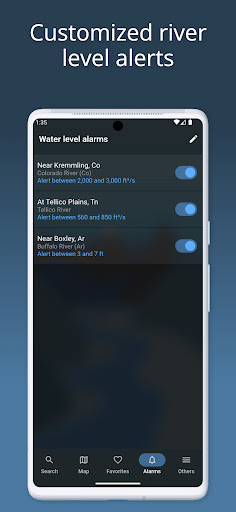
‣ Configuration of personalised alerts for each station when it has reached a defined value.
‣ Add stations or whitewater sections to favourites for immediate access to the latest readings and conditions.
FREE AND SPECIFIC FEATURES FOR WHITEWATER SPORTS:
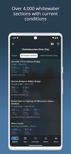
‣ More than 4000 referenced whitewater courses.
‣ Display of the navigability of courses according to water level or flow.
‣ Precise mapping of courses with quick access to put in and take out points.
‣ Display and publication of hazards (with photos) on routes.
‣ Information on the difficulty, length and average gradient of whitewater sections.
‣ Addition and modification of whitewater courses by the user community.
ADDITIONAL FEATURES WITH “RIVERAPP PREMIUM”:
‣ History of water levels and flows up to several years back.
‣ Flow or water level forecasts at certain stations.
‣ Display and comparison of satellite images on maps from several providers.
SOURCES:
- NVE
- California Data Exchange Center
- Government of Canada (Wateroffice)
- USGS
- NOAA
- PEGELONLINE (www.pegelonline.wsv.de)
- HVZ Baden Württemberg
- HDN Bayern
- Kanton Bern
- Ennskraftwerke
- Land Kärnten
- Land Niederösterreich
- NVE
- Regione Piemonte
- HVZ RLP
- Český hydrometeorologický ústav
- HVZ Sachsen-Anhalt
- Land Salzburg
- Scottish Environment Protection Agency
- Slovak hydrometeorological institute
- Agencija Republike Slovenije za okolje
- HWZ Steiermark
- BAFU
- HNZ Thüringen
- Land Tirol
- Shoothill
- Vigicrue
- Serveur de données hydrométriques temps réel du bassin Rhône Méditerranée
- Land Vorarlberg
- Bureau of Meteorology (Australia)
RiverApp and the listed organizations are not liable for any errors or omissions in the Information and shall not be liable for any loss, injury or damage of any kind caused by its use.
Download RiverApp - River levels
Not Available
Calificación Promedio
3.60K+
Desglose de Calificaciones
Reseñas Destacadas
Por Jo Beckett
2025-09-14
Versión 5.14.9
servicemonetizationcustomer_supportReally useful app for river levels. I asked the app creator to include gauges near me and he kindly did so. I use this a lot and even "splashed out" on the paid version to see trends over a longer time.
Por Sam Hubbard
2025-09-27
Versión 5.14.10
contentdesignserviceThe best river level app out there. Used it in multiple countries and the data availability all in one place in a easily navigable format is unrivalled
Por Bruce Skaarup
2025-09-18
Versión 5.14.9
serviceperformance_and_bugsThis app is accurate... I know what to expect when I reach my fishing destination. I've used it for planing trips also.
Capturas de Pantalla