onX Offroad: Trail Maps & GPS
onXmaps, Inc.
4.4
Détails de la Version
| Pays de l'Éditeur | US |
| Date de Sortie dans le Pays | 2023-07-26 |
| Catégories | Travel, Navigation |
| Pays / Régions | US |
| Site Web du Développeur | onXmaps, Inc. |
| URL de Support | onXmaps, Inc. |
| Évaluation du Contenu | 4+ |
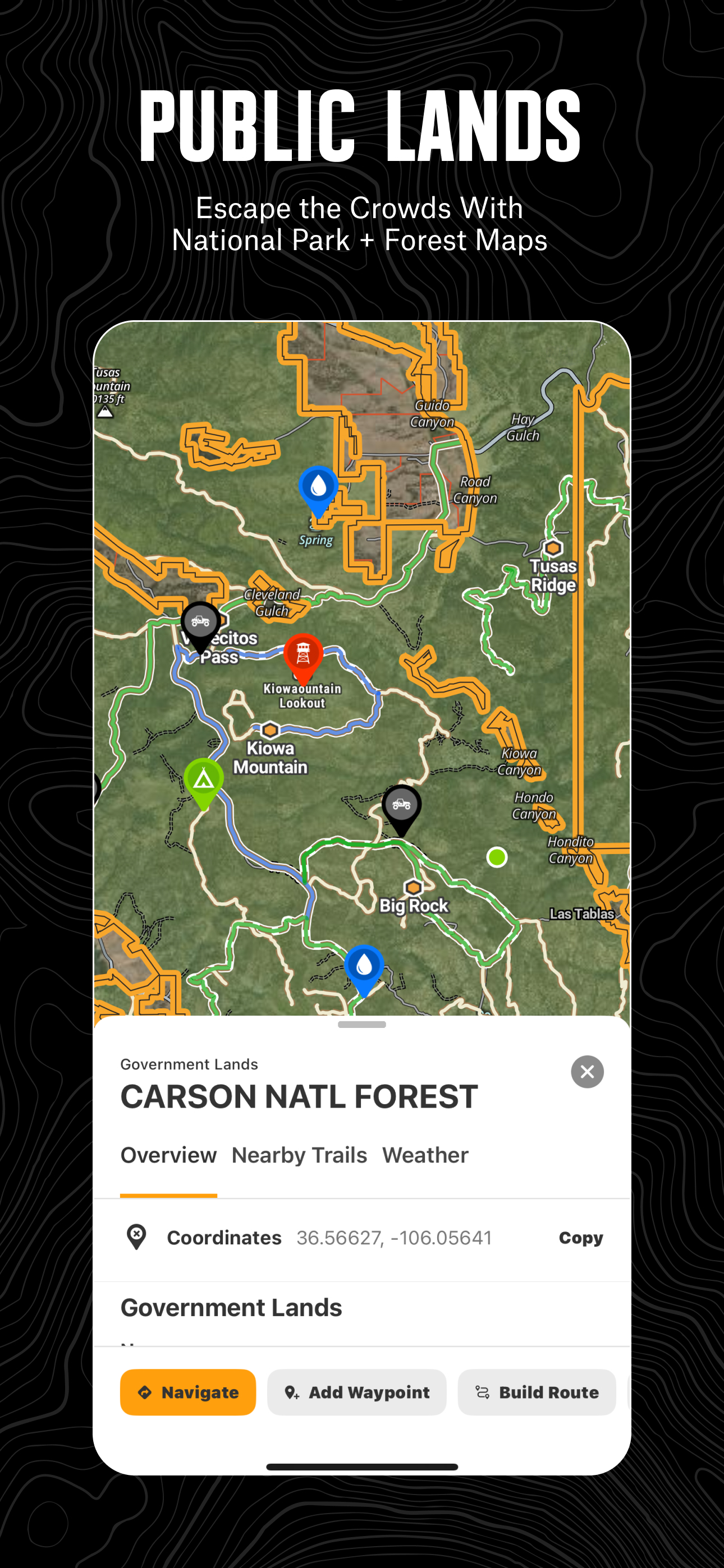
Navigate off-road and find the trails you’re looking for with onX Offroad. 3D trail maps, GPS mapping, and compass navigation — discover what’s open nearby or explore something new with ease.
Filter trails by accessibility for 4x4, SxS, dirt bikes, moto, ATV/Quads, Overland, and snowmobiles. Identify legal, free off-grid camping areas in National Forests using USFS verified data with our Motorized Dispersed Camping Layer. Go off-roading with the tools you need, including property lines, private landowner information, and acreage.
Track wildfire activity and stay safe during fire season with our built-in Active Wildfire and Wildfire Smoke Map Layers. Anticipate poor air quality and make informed decisions on the trail with NOAA’s Atmospheric Smoke Forecast data. Stay connected off the grid with Cell Coverage Layers that show up-to-date coverage for AT&T, Verizon, and T-Mobile.
Get directions from the tarmac to the trails with turn-by-turn navigation and sync onX Offroad with Apple CarPlay. Save Offline Maps to your phone or tablet. Find trailheads, trailer parking, non-ethanol fuel stations, campsites, and more.
Adventure starts where the pavement ends. Go where other maps can’t with onX Offroad.
onX Offroad Features:
▶ OHV Trails & Map Layers
• Find off-roading trails for your activity – SxS, 4x4, ATV, dirt bikes, snowmobiles, and more
• Toggle map layers for info on weather, land boundaries, and cell service
• Identify cell coverage areas for AT&T, Verizon, and T-Mobile
• Monitor wildfires and drifting smoke with data from the NIFC and NOAA
▶ Offline Navigation & Route Builder
• Explore 20K guided trails with open/close dates, difficulty ratings, and trail photos
• Save Offline Maps without losing interactive land and trail data
• Get off-road turn-by-turn directions with voice commands. Sync with Apple CarPlay
• Map routes that automatically snap to roads and trails
▶ Trip Tracker & Recreation Points
• Find legal dispersed camping spots along motorized trails in National Forests
• Track distance, location, speed or elevation. Save and share trips with friends
• Add Waypoints to mark campsites, fuel stations, fishing access, and more
• Customize maps by marking recreation points, rock crawls or obstacles
▶ Private Property Lines (Limited by Membership)
• GPS navigation and versatile map imagery – 3d, topo, satellite or hybrid
• Access private land ownership boundaries and information across the nation
• Identify National Forest, BLM, National Park land and more
Download onX Offroad and experience a trusted planning, mapping, and navigation app that always gets you home safely.
▶ Free Trial
Start a trial for free when you install the app. Experience the difference of a premier off-roading tool and plan your next adventure.
▶ Offroad Memberships:
Enjoy our premium features with an onX Offroad membership. Roam in parts unknown with the tools you need, including property maps and industry brand discounts.
• 650K+ miles of motorized roads and off-road trails
• Trails for 4x4, Side-by-Side, dirtbikes, dual sport, ATV, Quads, Overlanding, and snowmobiling
• 852M acres of public land across the U.S.
• 24K topographic maps and 3D maps for the entire U.S.
• Save Offline Maps for navigation without cell service
▶ Government Information & Data Sources
onXmaps, Inc. does not represent any government or political entity, though you may find various links to public information within our services. For more information on any government information found within the services, click on the associated .gov link.
• https://data.fs.usda.gov/geodata/
• https://gbp-blm-egis.hub.arcgis.com/
• https://www.arcgis.com/home/group.html?id=00f2977287f74c79aad558708e3b6649#overview
▶ Terms of Use: https://www.onxmaps.com/tou
▶ Privacy Policy: https://www.onxmaps.com/privacy-policy
▶ Feedback: If you have any trouble or have an idea of what you’d like to see in the app next, please contact us at [email protected].
Évaluation Moyenne
7.54K+
Répartition des Évaluations
Avis Sélectionnés
Par G. Riehl
2022-05-18
Version 22.17.0
accessibilityfeature_requestsgame_progressionlocalizationI have been using OnX Off-Road for a year now (Premium), and it has been a great tool for both navigation and trip planning. The map downloading works flawlessly, and the growing list of marked off-road excursions makes it fantastic for finding great spots. Living in the NorthEast, fun trails can be hard to come by, but even in the past year, lots more have been popping up. The photos and description of the trails is great for sizing up your ride. My biggest gripe about the app (which is minor) is that the search function is not very effective. You can find specific locations (coordinates, towns, names of trails or campsites). It would be great if you could search all of the campsites, waterfalls, or gas stations, etc. in a certain area, and they would be highlighted and compiled into a list. This would help out when planning a ride. Instead, I currently use other apps or maps to find these spots, then add waypoints in OnX. All in all, fantastic app that is an affordable and effective way of navigating in the backcountry and finding awesome spots that match your skill level and off-road setup.
Par TheOutlawTorn1999
2022-12-10
Version 22.47.0
gamificationfeature_requestsoffline_functionalityI got this app a year ago, and absolutely love it, I use it all the time in my personal life and sometimes even at work. The integrated private land plat is a fantastic feature for my research and planning for my general exploring, especially in the midwest where public land is scarce, and you have to find cool rough county roads that are designated public via the plat lines. There is a few features the app could have moving forward but in the year I've been using the app and talking with support and development, they are very focused on refining the app at all times. At the end of the day they are offroaders at heart too and want other offroaders to find success and fun outdoors, the bonus for them is that you use their app to help you get there, but that bonus is mutual because it is a valuable tool. This app will save a day or two a long the way if you use it long enough, I went to a trail in the East TN Appalachian Mtns. and the first choice I went to was closed (Hope they add a check in feature to help prevent this later on down the road, I believe they will). So I pulled up the app found another trail within 10 miles away, rerouted and still enjoyed my day offroading, there was very little service in this area too and the offline map I saved of the area backed me up and made sure I still made it despite the bad service. If you intend to offroad anywhere from a handful of times a year to every weekend or even more, On X is worth having.
Par FULLSENDCHEVYS
2023-04-04
Version 23.9.0
feature_requestslocalizationperformance_and_bugsI love this app. I have been using it since they first released it and it has never let me down. I was invited out to the Mojave Desert for a few days of wheeling and I couldn’t turn it down. I had to meet the group up later on due to work schedule, but that wasn’t stopping me from going out there alone. You see I had the OnX app. We took off into the night just my dog and I, to find the group on the outer edge of the preservation. We found them no sweat and set up camp for the night. The following day, the group organizers were explaining to everyone a few of the do’s and don’ts for the trip. I came to realize about 80 percent of the convoy had no idea where we were going. It was an amazing feeling to be able to have the confidence to know where I was going. It was miles of empty desert in every direction. It’s intimidating when you don’t know your bearings and everything looks the same. With the onXoffroad app there was no worry of getting lost. Another great feature is the ability to record your location and the exact trail or path you drove. If you need to double back to the beginning. Or if you enjoyed the trip that much, you can always go right back to where you started. This app is definitely worth the money if you regularly hit the dirt. FOLLOW FULLSENDCHEVYS on INSTAGRAM!!!!
Captures d'Écran