GOHUNT / Hunt Research & Maps
goHUNT LLC
4.4
Détails de la Version
| Pays de l'Éditeur | US |
| Date de Sortie dans le Pays | 2025-07-11 |
| Catégories | Maps & Navigation |
| Pays / Régions | US |
| Site Web du Développeur | goHUNT LLC |
| URL de Support | goHUNT LLC |
| Évaluation du Contenu | Everyone |
The only all-in-one hunting app where you can find, filter, navigate, and succeed on your next hunt. Trusted by diehard hunters like Randy Newberg, Remi Warren, and Ryan Lampers, GOHUNT is the leader in empowering hunters to overcome the challenges that face them in the field.
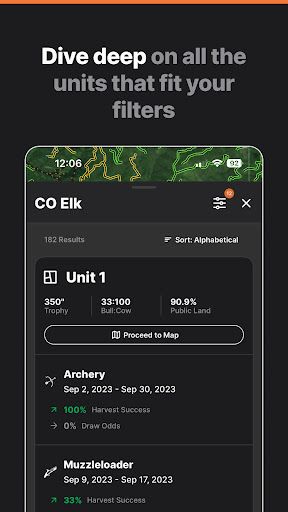
Our industry-leading hunt research platform helps you find every unit you’re able to draw a tag for. Select the state and species you want to hunt, then filter by your draw odds, the unit’s amount of public land, historical harvest success, and more. Then see a list of all the units that fit your criteria and see them directly in our mapping platform.
Our mapping platform is built for the needs of hunters across all 50 states. From the absolute basics like public & private land, waypoints, and roads & trails all the way to advanced 3D and analysis tools, you can access everything there is to know about any piece of land in the United States.
There’s no better platform to experience the power of having all your hunting tools in one place.
RESEARCH TOOLS
-Advanced search and filtering tools
-Draw odds for the west
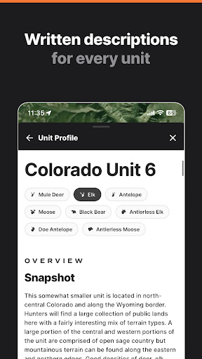
-Unit profiles for all western states
-Application strategies and deadlines
-Hunting tips and tactics
-Monthly gear giveaways
-Point Tracker for western states
MAPPING TOOLS
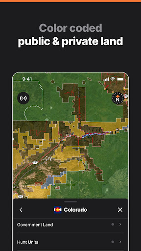
-Public/private land boundaries and ownership
-All 50 states included
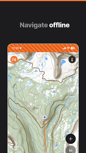
-Downloadable offline maps
-Hunt units and zones
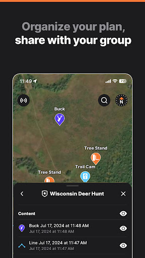
-Share waypoints, tracks, and hunts with other GOHUNT users
-Import data & waypoints from other mapping apps (web only)
-Hunt layers including land ownership, government land, species distribution, roads & trails, elevation bands, water, wildfire, and more
-Interactive 3D terrain
-Satellite, hybrid, and topographical basemaps
-Accurate GPS tracking
DESKTOP-ONLY TOOLS
-Terrain analysis tools
-Historical imagery library
-Reward points earned on all eligible purchases in the GOHUNT Gear Shop
Terms & conditions: https://www.gohunt.com/terms
Download GOHUNT / Hunt Research & Maps
Not Available
Évaluation Moyenne
1.27K+
Répartition des Évaluations
Avis Sélectionnés
Par Ross Collins
2025-08-28
Version 10.0.3
contentpricingcomparative_feedbackserviceHad high hopes as I was referred to this app. Paid for the full package, and after using it for a few months, I've become less than impressed. Topo lines are not detailed enough, I can't measure area only distance, landowner names aren't updated, and aerial imagery is only for one year. Im used to google Earth, our States GIS ortho and beacon, so maybe I am spoiled, but these are free compared to this subscription.
Par eric coulter
2024-10-23
Version 6.5.0
performance_and_bugscross_platform_consistencylocalizationoffline_functionalityupdates_and_maintenanceI hate to give a poor review because I really want this to work out. The mobile app is terrible. Once opened the maps will not refresh when I pan. Even when connected to wifi. I have to pan to desired location close the app then reopen. I can't believe I'm paying for this is where I am at. Update 10/23/24 Still having issues with the app. Error indicating too many layers and failing to load topo/sat when in the online mode. Desktop experience is great, draw odds and filtering are flawless.
Par Trevor Moore
2022-12-02
Version 2.3.9
feature_requestsupdates_and_maintenanceI have a lot of issues with this app. I have lost some of my saved data and it doesn't update real time. I need to continue to close it and bring it back up. Didn't work while I was out on my hunt and thankfully I had some backup maps. Go hunt, you have a lot of work to do on this app before I will use it for my Backcountry use. Not reliable. ********Latest update - all it took to resolve my issue was updating to the latest version of the app and all is working flawlessly now. Thanks Bransen!
Captures d'Écran